Everything Except Auxier Ridge

Map of Everything Except Auxier Ridge Hike, Red River Gorge

Elevation Profile of Everything Except Auxier Ridge Hike
Overview. This is an incredibly scenic route and was especially so with the lively clouds we enjoyed throughout the day. This hike visits seven named overlooks and four arches with a handful of unnamed overlooks to go with it. Mostly ridgeline hiking, be sure to pack plenty of water and electrolytes on hot days and leave a water cache if needed (we did) because there are zero reliable water sources on the route.
Route Type | Out and Back
Total Distance | 12.81 miles
Elevation Gain | 2,500 feet
Physical Demand | Moderate
Navigation Skill Level | Intermediate
this route uses mostly unmarked and unmaintained trails and is not suitable for novice off trail hikers; hike with an offline map using the .gpx file below and keep a copy of the waypoints to ensure you stay on track; check your track at all intersections to stay found
GPS Waypoints
Double Arch Trail Gate | 37.819772, -83.682728
Turn to “Cruise Liner Rock Trail” | 37.822053, -83.690122
Turn to Moreland Branch North Overlook | 37.820211, -83.696575
Moreland Branch North Overlook | 37.816344, -83.699025
Turn to 13 Rock Overlook | 37.822117, -83.702522
13 Rock Overlook | 37.821356, -83.702833
Get Lost Junction | 37.824344, -83.703686
Cruise Liner Rock | 37.827100, -83.708722
Turn to Sky View Arch | 37.824058, -83.705542
Sky View Arch | 37.824818, -83.705349
Turn to Star Gap Arch | 37.820533, -83.695578
Turn to Scramble | 37.821511, -83.695925
Star Gap Arch | 37.822569, -83.696085
Cul-de-sac | 37.830642, -83.687150
Rocky Branch Overlook | 37.830597, -83.688114
Rainbow Point | 37.833156, -83.688167
Double Arch Singletrack Start | 37.830444, -83.686508
Double Arch | 37.837462, -83.683998
Red River Gorge Area Map
Parking. Ample parking is available at the Auxier Ridge Trailhead that routinely fills up on nice weather weekends. Be sure to arrive early or late to find a parking spot. Visit Sunday midday through Friday morning, and you’ll usually find plenty of space to park. The parking lot has a pit toilet and bear proof trash bins.
Trail Navigation. Most of this hike is on unmarked and unmaintained trails that are well trod, but the proliferation of side trails can result in getting temporarily lost. Be sure to upload the .gpx file to your offline map app and keep the waypoints with you to stay on the route. Here is the navigation in simplest terms with nearly all turns being to the left:
Start at the gate at the roundabout on Double Arch Trail
Walk the gravel road and keep your eyes to the right to look for a wide uphill dirt trail at about mile 0.15
Take the turn and cross through a large campsite, then a smaller campsite, and finally arrive at the top of Arch of Triumph
Drop down from the exposed rock (pictured below) on the left side and take in the view of Arch of Triumph
Retrace your steps back to the main trail and turn right to continue out on Double Arch Trail’s gravel road section
About a half mile after rejoining Double Arch Trail, there is a fork with a wide dirt trail on your left; take this trail to Cruise Liner Rock and a whole lot more
Pass the Forest Service gate and continue following the main path past all the user trails that split off of it
Come to a decent sized campsite next to a downed tree and notice the fork ahead of you; go left
Continue on this ‘junkyard spur’ past a truck cab and plenty of other debris; some narrower paths exist here that go to a twin arch, but stay on the most well trod path
Go through some scruff and reach Moreland Branch North Overlook
Retrace your steps back to the big fork by the campsite and make a sharp left to continue the route
Walk the ridgeline going up and down until reaching a kind of mini-roundabout with a patch of vegetation in the middle; turn left here to reach 13 Rock Overlook
Continue to the overlook and take in the views; find the number 13 carved into the rock that gives this overlook its name; and NEVER carve rocks
Retrace your steps to the mini roundabout and go left to continue on the ridgeline
Eventually, you’ll make your way to an equally worn split that I call Get Lost Junction; take a left and proceed through some rhododendron
Keep going out on the ridge and take in the unnamed overlooks along the way until finally reaching Cruise Liner Rock
Retrace your steps back to the waypoint for the spur to Sky View Arch; you’ll be able to see Cruise Liner Rock from a few paces from the spur trail
Descend carefully through the dirt scramble section and hug the cliffline to reach the arch
This is a pristine arch, so keep it that way - no carving, no spray painting, no fires, no smoke, no trash
Return to the main trail and turn left to continue back past the turns for 13 Rock and Moreland Branch North Overlooks
Turn left and go downhill at the waypoint for the spur to Star Gap Arch
There are at least three well defined paths leading to scrambles - I like the second one best
Drop down and then move north on the side of the ridge past another short scramble and arrive at Star Gap Arch; enjoy the view and the breeze
Track back to the main trail and turn left
Pass the gate and go left at the fork to return to the gravel road
Shortly thereafter, look for the wide trail on the left and take that to Jailhouse Rock
This passes a large campsite and a couple more that progressively get smaller as you get closer to Jailhouse Rock
Use the most well trod path meandering up and down the ridge with a couple short but manageable scrambles
The final approach to Jailhouse Rock is uphill and a survey marker is staked in the ground
Walk out to the overlook and enjoy the expansive views
Retrace your steps back to the gravel road and turn left
Continue to the end of the road at the cul-de-sac and go left over the downed tree and descend to Rocky Branch Overlook
Walk back uphill and look for the sign post at the end of the cul-de-sac; the spur trail to Rainbow Point is the narrow path going downhill to the right of the sign
Continue out to the point by passing the campsite and long rock bench on your left; go uphill and at the top, turn left
Descend to Rainbow Point and enjoy the views; noticing Rocky Branch Overlook to your left up the hollow, Jailhouse Rock across from you, and Red River off to the North
Retrace your steps to the cul-de-sac and take the singletrack Double Arch Trail on your left downhill and down a good number of stairs
Follow Double Arch Trail and continue left at the fork with Auxier Branch Trail
Continue in the forest and wrap around the nose of the ridge before passing Serpent Rock on your left
Keep going on trail and up the stairs to reach Double Arch; explore The Observatory above by taking the carved rock stair up
Retrace your steps back to the cul-de-sac and turn left to follow the gravel road back to the parking lot
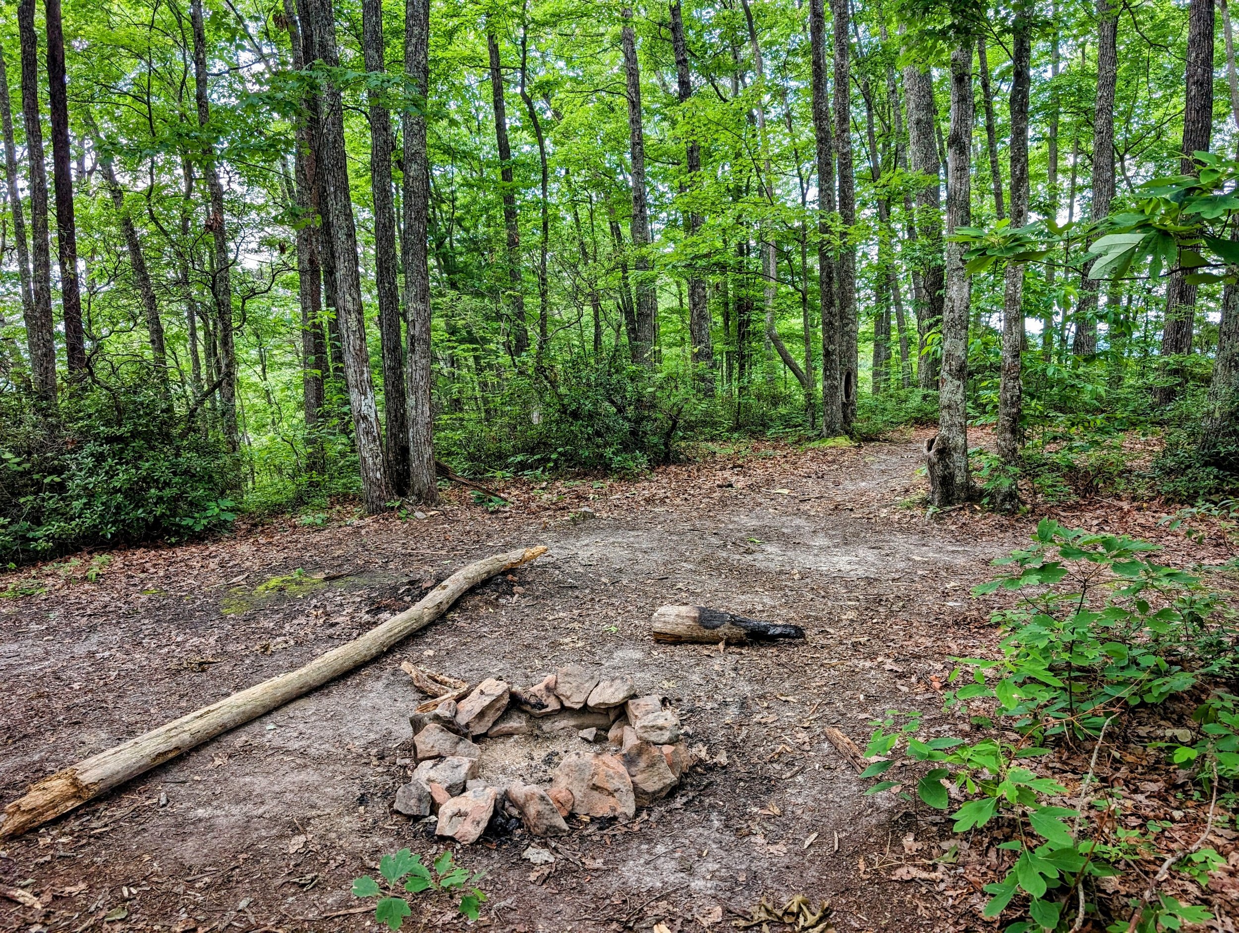
RULE REMINDER - No fires within 100 feet of arches or rock shelters. Fires can irreparably damage arches and rock shelters. Heat can force water in rocks to expand and crack the rock. Plus, the smoke stains last a long time because water doesn’t often run underneath these types of rock formations. The fire ring we destroyed had a freshly cracked piece of sandstone in it.
HIKER NOTE - The Observatory. Above Double Arch is The Observatory that has some terrific views. We skipped it with lightning in the air, but it’s a short scramble up chiseled steps with the only challenge being that first step up/the last step down. The stairs are located to lookers’ right of Double Arch.
HIKER NOTE - Shorter Route. While I love Cruise Liner Rock and the unnamed overlooks out that way, that segment has much thicker underbrush than the rest of the route. You can cut the route short at Sky View Arch for a less bushwhacky feeling kind of day.
HIKER NOTE - Summer Sunrise at Jailhouse Rock. Sunrise at this spot is great anytime, but nearest the Summer solstice is likely the best time to be there.
CAUTION - No Water. There is no reliable water source on this route, so carry extra water and electrolytes on hot days; cache water if needed (we stashed water at the Forest Service gate; use collapsible water bags to make it easy to carry them out with you)
CAUTION - Deadly Drops. Long falls from high places are the #1 non-health related cause of death for hikers in Kentucky. Keep your distance from the edges of cliffs to avoid a deadly fall. Young children should be kept close.
CAUTION - Poisonous Snakes. Copperheads and timber rattlesnakes can be found in the area. Should you encounter one, stop and slowly back away. Always give venomous snakes a wide berth. Know Before You Go => University of Kentucky Venomous Snake Guide
CAUTION - Black Bears. Ursus Americanus - a.k.a. the American black bear is growing in population throughout much of Kentucky. Know Before You Go => US Forest Service Black Bear Safety Tips

Double Arch Trailhead

Drop down on the left side to reach Arch of Triumph
Arch of Triumph; it’s a shear drop on the far side, so take care here

Turn left to depart Double Arch Trail and begin the spur out to Cruise Liner Rock

Old road gate

You’ll pass a downed tree where the trail has re-routed through a campsite coming to this fork; go left for Moreland Branch North Overlook

This could also be called the junkyard trail segment

Looking over Moreland Branch

Take the left fork to 13 Rock Overlook

13 Rock Overlook

Lots of user trails spur off the main trail; use a topo map or offline gpx generated map to stay on the route; nearly all spur trails lead to an overlook and/or campsite

A sweet little knob between Cruise Liner Rock ‘Trail’ and the Mountain Parkway

One of many unnamed overlooks

Cruise Liner Rock

View from Cruise Liner Rock

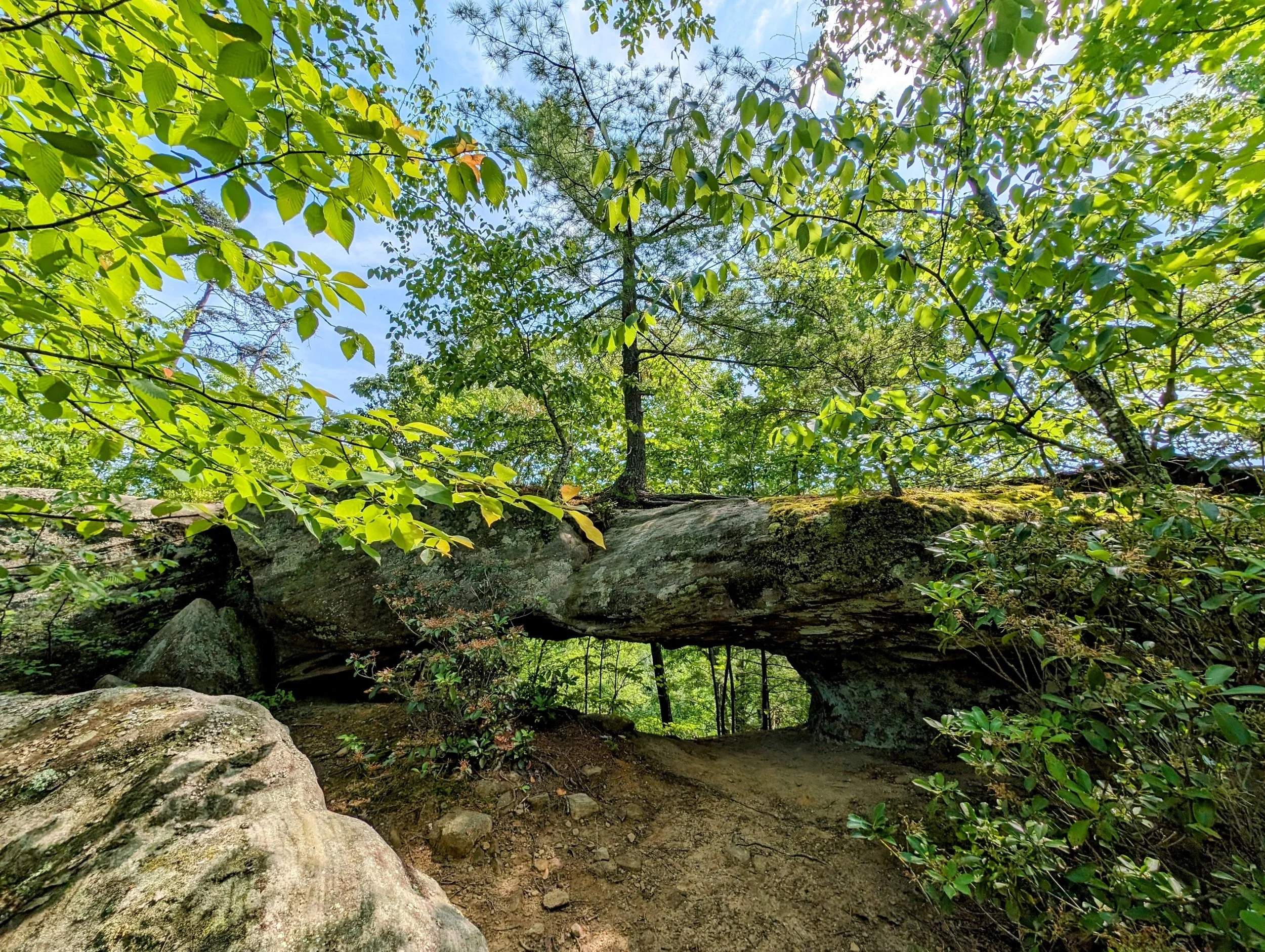
Take the narrow path downhill on the left to Sky View Arch

Sky View Arch approach view

Sky View Arch from below

Trash-holes; pack your shit out and NEVER build a fire within 100 feet of an arch or rock shelter; heat and smoke and do irreparable damage

Pack out what others leave behind and destroy illegal fire rings leaving no trace for other trash-holes to imitate

Larry Patton pointing to the rifling pattern that can be found in certain rock layers throughout the Gorge

Not a good look on me, but LaFonda will be happy when she loses her next pair of shades

Cruise Liner Rock from above Sky View Arch

Turn to Star Gap Arch; just remember it’s on your left and goes downhill when you’re coming back from Cruise Liner Rock

Short scramble down toward Star Gap Arch

Star Gap Arch approach view

From the backside of Star Gap Arch

We were heading north from here and left the trash in the center of the trail for other hikers to take back to the trash bin; we passed a pair of hikers shortly after this and asked them to pack it out

Turn to Jailhouse Rock

Large, heavily impacted campsite en route to Jailhouse Rock

Another short scramble
Smaller campsite nearer Jailhouse Rock

View south from Jailhouse Rock
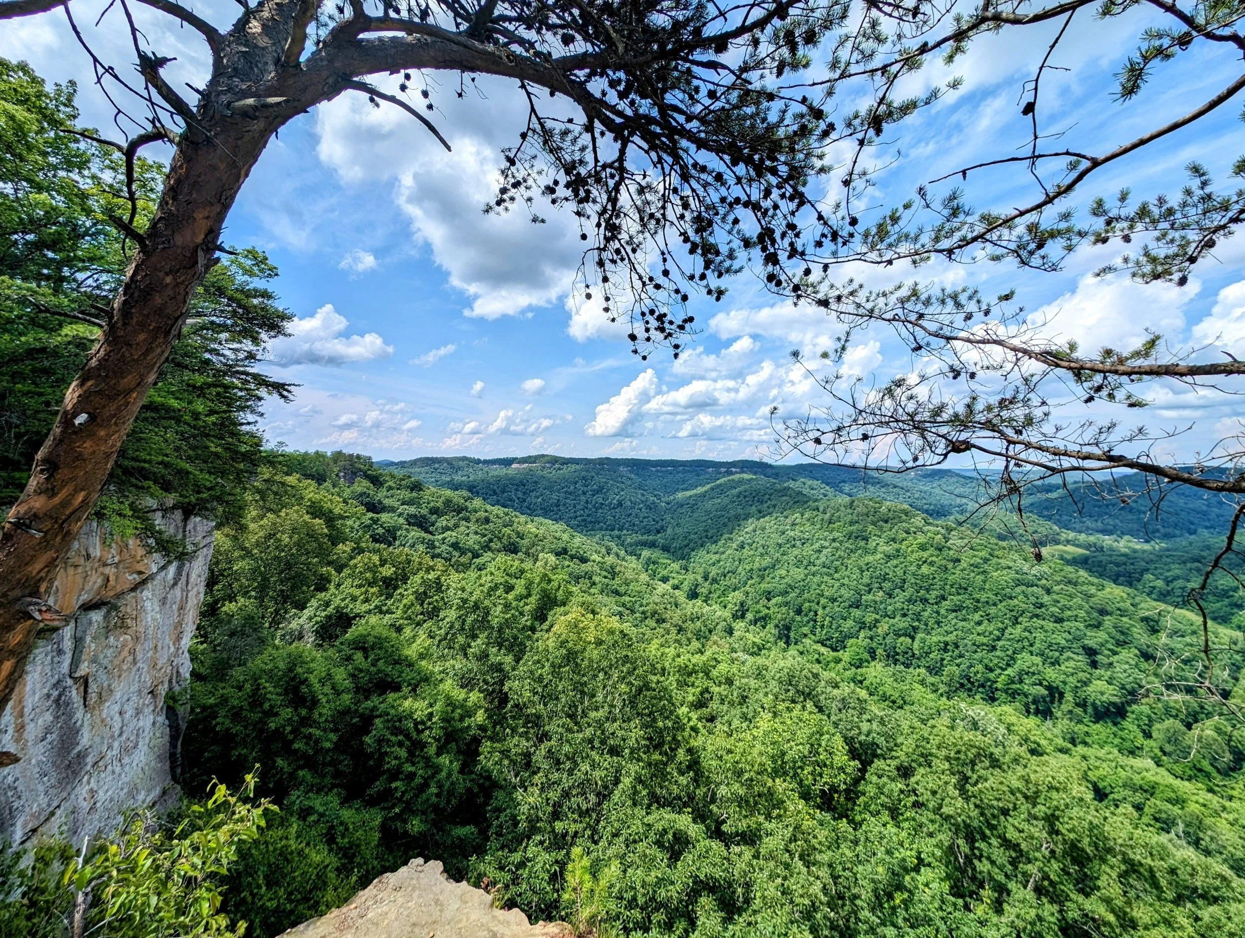
View North from Jailhouse Rock

View east to Rainbow Point from Jailhouse Rock

Wide angle view east-northeast from Jailhouse Rock
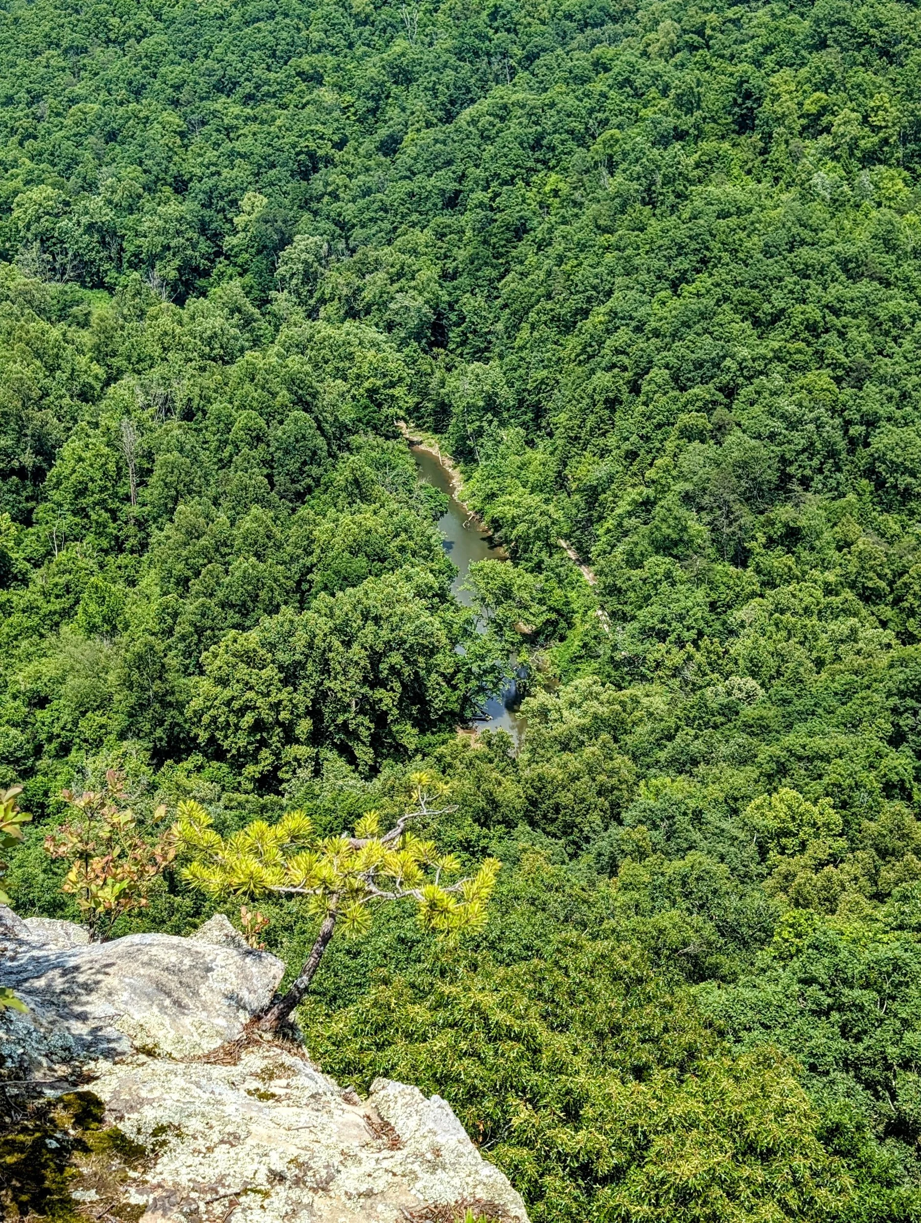
Looking down to Red River

End of the road, go left for Rocky Branch Overlook

View north-northwest from Rocky Branch Overlook

Take the downhill path to the right of this sign to Rainbow Point

View of Rainbow Point from a campsite on the route

The rainbow in Rainbow Point is more colorful during golden hour

View north-northwest from Rainbow Point

Dropping down to the singletrack section of Double Arch Trail

Only a mile to the goodies!

We interrupt your regularly scheduled programming for a hornets nest with at least one angry hornet that stung me:-)

Take the left fork to Double Arch (right to Courthouse Rock and Auxier Ridge)

Serpent Rock a.k.a. Snake Rock

Double Arch approach view

Double Arch framing Auxier Ridge

Final look out to Auxier Ridge as thunderstorms rolled in

How many hikers did it take to clean up after some trash-holes? 4. Larry and I cleaned and hauled from Sky View Arch to Double Arch Trail and two random trail badasses brought it to the finish line. Teamwork does, in fact, make the dream work!