Sand Gap, White’s Branch Arch, Ramp Arch, Twilight Arch, Natural Bridge, and Rock Garden Window Complex

Map of Sand Gap, White's Branch Arch, Ramp Arch, Twilight Arch, Natural Bridge, and Rock Garden Windows Complex - Red River Gorge

Zoom View of White's Branch Arch Area, Red River Gorge

Elevation Profile of Sand Gap, White's Branch Arch, Ramp Arch, Twilight Arch, Natural Bridge, and Rock Garden Windows Complex - Red River Gorge
Overview. There’s nothing to see, then there is a ton to see! This hike has some beautiful forest walking for the first 4+ miles before reaching the ridgeline to four arches, four overlooks, and plenty of amazing geology. The hike is moderately difficulty overall, but a class 4 scramble is required to reach White’s Branch and Ramp Arches. Overall, this is one of the best 10+ mile routes in the Red River Gorge Region, but can be made shorter with more direct approaches (see hiker notes below).
WARNING! If you do not have the ability to descend/ascend via rope, do NOT attempt the White’s Branch and Ramp Arches portion of the hike. Serious injury or death are waiting for those unfit to execute the scramble. The other overlooks and arches are more than enough for a great day on the trails.
Route Type | Loop and Spurs
Total Distance | 11.11 miles
Elevation Gain | 1,994 feet
Overall Difficulty | Moderate with Class 4 Scramble (Rope Required)
GPS Waypoints
Sand Gap/Hood Branch Trailhead | 37.781642, -83.691119
Turn to Sand Gap Trail | 37.780733, -83.690711
Sand Gap - Sheltowee Trace Junction | 37.761153, -83.700622
Turn to White’s Branch Arch | 37.752700, -83.700661
White’s Branch Arch | 37.752761, -83.700875
Turn to Ramp Arch | 37.752464, -83.700953
Ramp Arch | 37.753256, -83.701575
Turn to Overlooks and Twilight Arch | 37.754103, -83.701358
Split to Crow Drive Creek Overlook or Twilight Arch | 37.753944, -83.701803
Crow Drive Creek Overlook | 37.753542, -83.704656
Twilight Arch and Overlook | 37.752750, -83.702858
Turn to Natural Bridge | 37.771614, -83.684825
Natural Bridge | 37.773050, -83.685453
Turn to Rock Garden Trail | 37.773156, -83.685617
Rock Garden Windows Complex | 37.773331, -83.686575
Turn to Low Gap | 37.781006, -83.688047
Low Gap Trailhead | 37.782067, -83.689536
Natural Bridge State Resort Park Map
Parking. Ample parking is available in the Sky Lift parking lot with bathrooms, trash receptacles, and soda vending machines.
Trail Navigation. This hike is relatively easy and covers mostly marked trails. The unmarked portion is zoomed in on the map above for your reference while you’re out there. Be sure to download the .gpx or .kml file to aid you in navigation. Begin by locating the Hood’s Branch Trailhead by the putt putt course and bathrooms at the Sky Lift parking lot. Walk uphill on Hood’s Branch Trail before reaching the intersection with Sand Gap Trail about a tenth of a mile in. Turn right (west) and continue climbing. This trail meanders around some knobs before finally gaining the ridge at mile 4.3. Keep going until reaching the intersection with Sheltowee Trace at mile 5.7. Take a right (southwest) to follow the Trace along the ridge, walking over exposed rock that can be slick when wet. Eventually, you’ll reach the top of White’s Branch Arch (GPS waypoint above). Look right (west) to see a well worn path that descends steeply using rock ledges. Get to the corner where the rock is split and locate the rope that you’ll use to descend. It is affixed to a root and roots eventually break, so be sure to test before you trust. Scramble down carefully and go right (north) along the cliff wall following the path. White’s Branch Arch will come into view shortly. Enjoy your time there taking in the arch and the view above the holler. Retrace your steps and find the disturbed soil that is the path to Ramp Arch. Move downhill carefully and turn right to hug the next level of the cliff face. You’ll move slightly away from the cliff line only a couple times and only a couple paces. Continue around past the elbow of the rock face before seeing Ramp Arch - likely named after the top portion of the arch that could easily pass for a ramp. Walk underneath the arch to find the narrow opening directly above and enjoy the incredible rock features both above and below. For me, the rock wall and fallen chunks were the most impressive feature of this hike. Once you’ve finished here, retrace your steps, ascend the rope, and head back to the Sand Gap Trail/Sheltowee Trace intersection. From that junction, continue northeast toward Natural Bridge. The path here is ridgetop, wide, and easy - making for fast travel. Once you reach the next intersection, head north to reach the Natural Bridge area with a covered pavilion marking the final turn (left) to reach the top of the bridge. Enjoy the views here and then descend through the squeezer to reach the base of the arch. Grab a few pics of this behemoth before going to the far side to reach Rock Garden Trail. Take this trail and keep your eyes right to enjoy the wide variety of erosion patterns in the cliff face and find the Rock Garden Windows Complex. This is a gorgeous scene and some of the windows are delicate, so look, but don’t touch. Continue around the cliff face before reaching the final descent to the parking lot on Low Gap Trail. The descent from Natural Bridge is quite steep with many hand carved stone steps made many decades ago. Reach the parking lot and hit up the vending machines in season to enjoy an Ale-8. You will have earned a cold one by this point!
HIKER NOTE - Save Miles. This hike can be shortened ~2.7 miles by making it an out and back from Low Gap Trailhead. In exchange for the shorter hike, you’ll add a steep opening ascent to Natural Bridge;-) Oddly, the same mileage can be achieved starting at Lakeside Trail, then up Original Trail, and out on Sand Gap Trail to the White’s Branch Arch area on the zoomed in map above.
CAUTION - Deadly Drops. Long falls from high places are the #1 non-health related cause of death for hikers in Kentucky. Keep your distance from the edges of cliffs to avoid a deadly fall. Young children should be kept close.
CAUTION - Poisonous Snakes. Copperheads and timber rattlesnakes can be found in the area. Should you encounter one, stop and slowly back away. Always give venomous snakes a wide berth. Know Before You Go => University of Kentucky Venomous Snake Guide
CAUTION - Black Bears. Ursus Americanus - a.k.a. the American black bear is growing in population throughout much of Kentucky. Know Before You Go => US Forest Service Black Bear Safety Tips

Hood's Branch Trailhead, Red River Gorge

Natural Bridge State Park Nature Preserve Rules, Red River Gorge

Blue Blaze for Hood's Branch Trail, Red River Gorge

Hood's Branch and Sand Gap Trail Intersection, Red River Gorge

Sand Gap Trail Blaze, Red River Gorge

Mile Marker to Natural Bridge, Red River Gorge

First View from the Ridge on Sand Gap Trail, Red River Gorge

Fence at Sand Gap Trail and Sheltowee Trace Junction, Red River Gorge

Sheltowee Trace Blazes, Red River Gorge

Take the Dirt Path on the Right (west) to White's Branch and Ramp Arches, Red River Gorge

View from Above White's Branch Arch, Red River Gorge

Climbing Rope Affixed to a Tree Root, Red River Gorge

Fixed Rope, Red River Gorge

First View of White's Branch Arch, Red River Gorge

White's Branch Arch from the Far Side, Red River Gorge

Looking East from Inside White's Branch Arch, Red River Gorge

White's Branch Arch, Red River Gorge

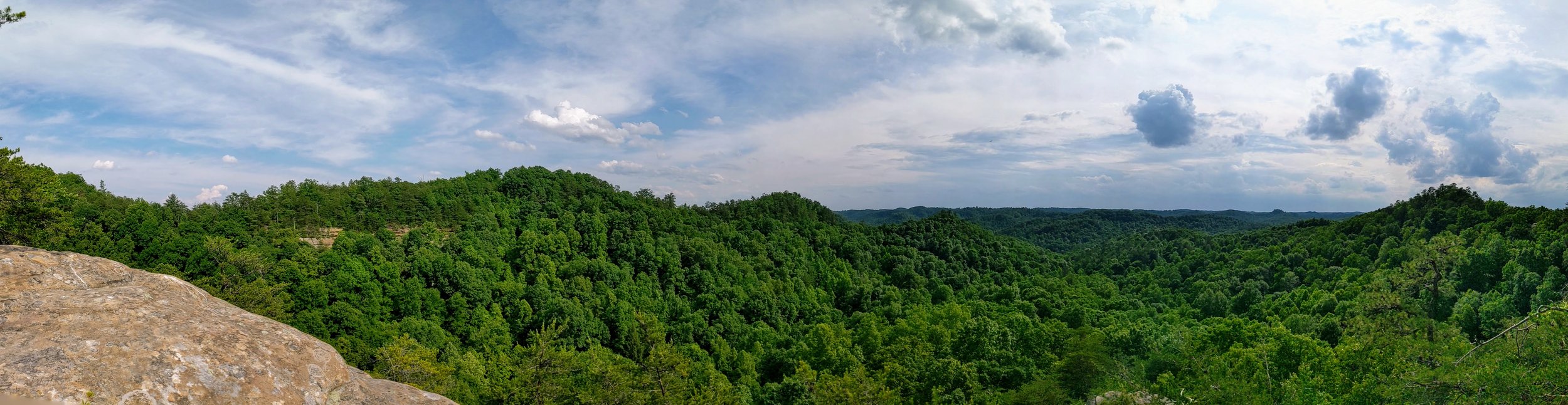
180-degree Pano of White's Branch Arch and Hollow, Red River Gorge

Descent to Ramp Arch - Disturbed Leaf Litter Means Hikers Have Been Here, Red River Gorge

Ramp Arch Coming Into View, Red River Gorge

The 'Ramp' of Ramp Arch, Red River Gorge

Glowing Underbelly of Ramp Arch, Red River Gorge

The Crack That Makes Ramp Arch an Arch, Red River Gorge

Geology Akin to That Seen in Caves, Red River Gorge

Strange Rock Erosion Pattern, Red River Gorge

The Weirdest Rock I've Seen, Red River Gorge

Before PBR, There Was Pabst, Red River Gorge

Trail Split - Left for Sheltowee Trace Southbound or Right for Crow Drive Creek Overlook and Twilight Arch and Overlook, Red River Gorge

Trail Split - Left for Twilight Arch and Overlook or Right for Crow Drive Creek Overlook, Red River Gorge

View from Crow Drive Creek Overlook, Red River Gorge

Looking Back at Crow Drive Creek Overlook, Red River Gorge

Twilight Arch, Red River Gorge

Western View from Twilight Arch Overlook, Red River Gorge
Pano Shot from Twilight Arch Overlook, Red River Gorge

Woodland Sunflower, Red River Gorge

Storm Clouds Rolling In from Unnamed Overlook, Red River Gorge

Trail Split - Left for Natural Bridge or Right for Sheltowee Trace, Red River Gorge

Looking at the Top of Natural Bridge, Red River Gorge

View from the Top of Natural Bridge, Red River Gorge

Squeezer at Natural Bridge, Red River Gorge

Looking Up at Natural Bridge, Red River Gorge

Natural Bridge from Junction with Original Trail, Red River Gorge

Turn to Rock Garden Trail, Red River Gorge

Yellow Blazes Mark the Way on Rock Garden Trail, Red River Gorge

A Gorgeous Rock Wall, Red River Gorge

Rock Garden Window Complex, Red River Gorge

View from Below Sky Lift, Red River Gorge

False Arch on Rock Garden Trail, Red River Gorge

Hand Chiseled Decades Old Stone Steps, Red River Gorge

Final Turn on to Low Gap Trail, Red River Gorge

Low Gap Trailhead, Red River Gorge

Ale-8-One Orange Cream Soda from the Vending Machine - Red River Gorge