Sheltowee Trace Section Hike - Scenic Alternate - Corner Ridge Road to Red River with Indian Staircase, Shawnee Arch, Frog’s Head, and Adena Arch and Overlook


Overview. This scenic alternate adds the iconic Indian Staircase along with a couple arches, plenty of views, and the expansive Council Chamber. Most find it easier to hike this southbound to take advantage of the net descent and provide uphill access to Indian Staircase. Scrambling is required.
Route Type | Point to Point
Total Distance | 11.10 miles
Southbound Elevation Gain | 1,562 feet (Coros)
Southbound Overall Difficulty | Easy to Moderate with Class 2/3 Scrambles
Northbound Elevation Gain | 2,064 feet (Coros)
Northbound Overall Difficulty | Moderate with Class 2/3 Scrambles
this route uses unmarked and unmaintained trails; scrambling skills required; not suitable for inexperienced off trail hikers; read the cautions and notes in full before attempting this hike
GPS Waypoints
Corner Ridge Road Trailhead | 37.886550, -83.593347
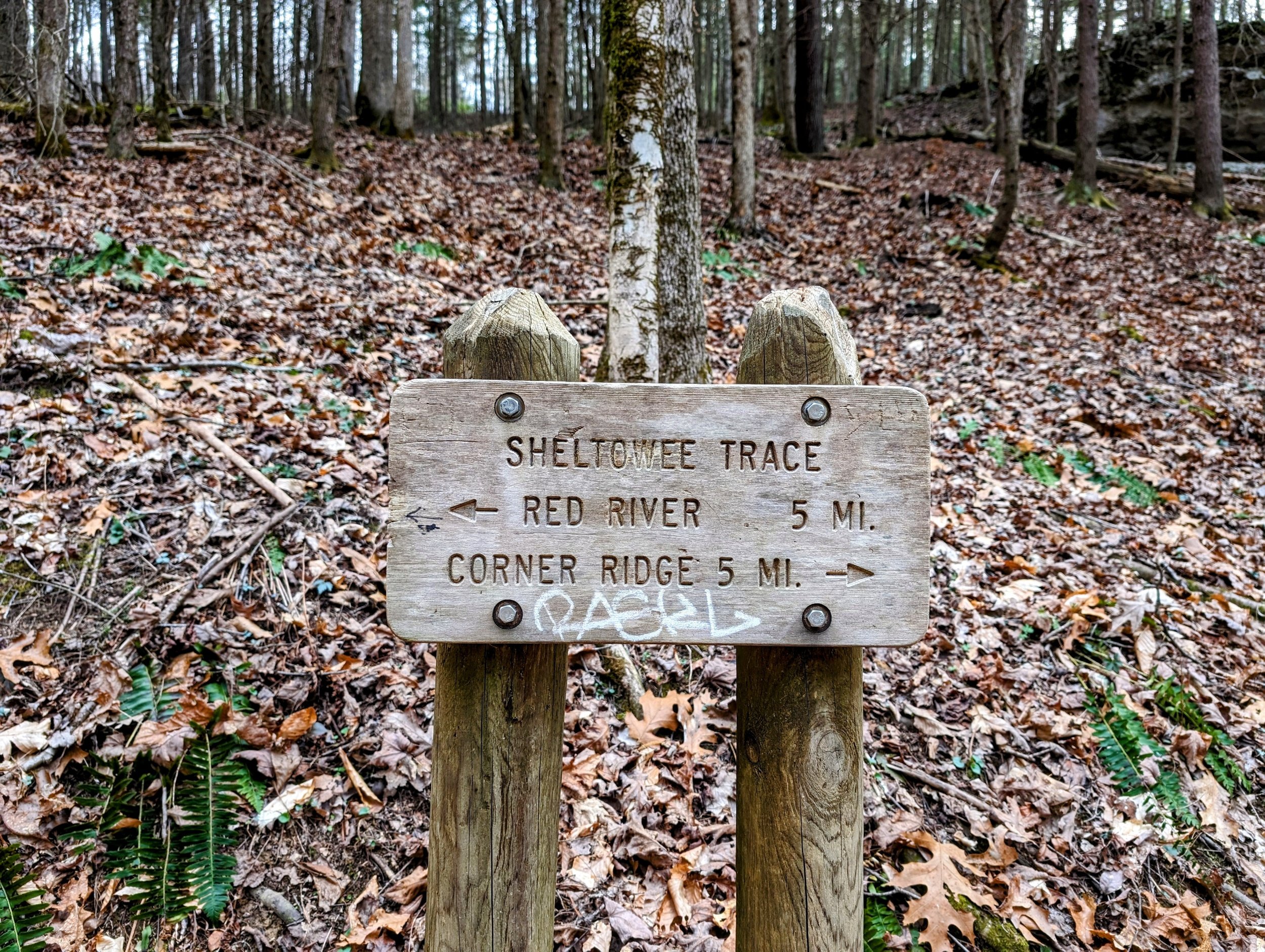
Sheltowee Trace/Lost Trail Junction | 37.856433, -83.593922
Sheltowee Trace/Bison Way Junction | 37.842681, -83.611258
Turn to Indian Staircase | 37.844347, -83.614225
Top of Indian Staircase | 37.846224, -83.615890
Shawnee Arch | 37.8467139,-83.6162306
Frog’s Head | 37.846963, -83.616787
Council Chamber Rock Shelter | 37.847511, -83.619267
Sheltowee Trace Junction | 37.842706, -83.617000
Turn to Adena Arch | 37.842403, -83.615936
Adena Arch and Overlook | 37.839147, -83.612342
Indian Arch | 37.842883, -83.616144
Sheltowee Trace Suspension Bridge | 37.827925, -83.624492
Jump Rock Access | 37.824156, -83.625775
Sheltowee Connector Trailhead | 37.823102, -83.628063
Red River Gorge Area Map
Parking. Limited parking is available at the Corner Ridge Road Trailhead at the end of the paved road. Do not block the neighbor’s driveway.
Trail Navigation. For most of this hike, you’ll be on Sheltowee Trace passing a number of marked and unmarked trails along the way. Pay special attention to the navigation instructions below and be sure to head out with the .gpx file loaded to your offline topo map. Here is the turn-by-turn:
Start at the Corner Ridge Road Trailhead and follow the forest road downhill until you near Gladie Creek
At the Lost Trail Junction, descend to your right (west) to continue on Sheltowee Trace
Continue straight past Bison Way Trail Junction
After a few dozen paces, cross a stream and keep your eyes to the right to find the unmarked and unmaintained spur to Indian Staircase; this is a 6’+ wide trail with exposed rock at the intersection that’s hard to miss
Continue uphill and scramble through a badly eroded section with exposed roots and plenty of rocks
Continue uphill to reach the base of the exposed rock section and do your best with wayfinding to reach the footholds section that is Indian Staircase; note that the route to the base of the footholds zig zags a bit, so the safest path may be to one side or the other before ascending the rock staircase
Reach the top of the staircase and turn left
Keep your eyes left, your feet on flat surface, and your body plenty far enough away from the cliff’s edge
Notice Shawnee Arch downhill and continue around the gorge rim
Come to Frog’s Head and continue past it keeping your eyes left for a wide descending path over exposed rock to reach Council Chambers
Stay behind the fence and do not disturb the white haired goldenrod habitat - this is an endemic species that only grows in Red River Gorge’s rock shelters
Continue around the rock shelter and ascend on singletrack that narrows and at times is only inches away from the open air/death below - be extra careful with your balance here
Ascend opposite Indian Staircase to emerge at a campsite and turn left
Continue to follow the user trail and reach Sheltowee Trace
Turn left at the Trace and continue out to Adena Arch and Overlook (you’ll go straight at a sharp turn on the Trace)
Retrace your steps back to the Trace and take the right fork to reach Indian Arch
Turnaround at Indian Arch and proceed southbound on Sheltowee Trace keeping left at the unmarked junctions that lead to the Indian Staircase user trail network
Continue to meander through the forest on the Trace until crossing KY-715 and reaching the suspension bridge
Turn right and follow alongside the river downstream to reach Jump Rock access and Sheltowee Connector Trailhead - home to the nastiest port-o-let in Red River Gorge:-)
Water Sources. You can filter water at Red River, Klaber Branch, Gladie Creek, or Salt Fork. If continuing northbound, top off at Salt Fork before heading uphill to Corner Ridge. If continuing southbound past the river, top off at Chimney Top Creek before continuing up toward Tunnel Ridge (next stop for water after the ridge is Whittleton Branch.
HIKER NOTE - Shuttle Service. Leave No Trace Adventures provides shuttle service that can be booked in advance. Park your car at the end of your route and get a shuttle to where you’ll begin. There are few things more annoying than waiting for a shuttle after you’ve hiked a big day and finished where you have zero cell service. Just waiting. And waiting. And waiting. And for that reason…ALWAYS leave a car at your destination!
CAUTION - Eroded Stream Crossing. The trail has significant erosion at stream crossings feeding Gladie Creek. Use caution on these sections - especially when wet or frozen.
CAUTION - Indian Staircase. Never attempt to ascend/descend this when wet, icy, or snowy. Turn the loop into an out and back instead using the south junction of the loop. When ascending, bear crawl up and utilize the footholds. When descending, crab walk down scooting your butt as you go. It is exceedingly rare than anyone run into problems using these techniques - it is only dangerous if you use poor technique, hike in poor conditions, or have a mental freakout when you’re up there. First-timers should hike this with others who have been there. Ideally, one experienced person in front and one behind.
CAUTION - Indian Staircase Mid-Level Loop. You will be inches from a long fall off the cliff at various points on this loop. If you’re afraid of heights, take the top-level loop by continuing above Council Chamber because the mid-level trail is very thin in spots. You can drop down to Council Chamber from the top-level between the rock shelter and Frog’s Head and retrace your steps and turn left to circle the rim’s highest trail.
CAUTION - Deadly Drops. Long falls from high places are the #1 non-health related cause of death for hikers in Kentucky. Keep your distance from the edges of cliffs to avoid a deadly fall. Young children should be kept close.
CAUTION - Poisonous Snakes. Copperheads and timber rattlesnakes can be found in the area. Should you encounter one, stop and slowly back away. Always give venomous snakes a wide berth. Know Before You Go => University of Kentucky Venomous Snake Guide
CAUTION - Black Bears. Ursus Americanus - a.k.a. the American black bear is growing in population throughout much of Kentucky. Know Before You Go => US Forest Service Black Bear Safety Tips

Corner Ridge Road Trailhead

Trailhead sign and infoboard

Triangle split - go right for Sheltowee Trace Southbound

Official trail junction at Lost Trail/Sheltowee Trace - go right and downhill
Almost halfway; Bison Way Trail Junction

Split to Indian Staircase - go right and uphill to reach the staircase

First scramble section over roots and rocks

There used to be dirt here, but not anymore

Lower staircase - initial footholds are well worn and slick

Upper staircase

View from the top of Indian Staircase on an overcast day

Shawnee Arch - use extreme caution if taking a more up close look at the arch

Approach to Frog’s Head

Frog’s Head and the Sacrificial Altar

Looking back at the cliffline

A look ahead to around the rim

Bare rock pointing the way down to Council Chamber

Council Chamber is much more impressive in person

Stick your head in here and talk it out with yourself; geologically speaking, this is a hueco

View of Indian Staircase from across the way

Continue straight to Adena Arch/Overlook

Approach to Adena Arch/Overlook

Adena Arch and Fido

View from Adena Overlook

Take the right fork to Indian Arch

Indian Arch fore view

Indian Arch aft view

Stay left to continue on the Trace (right is the Indian Staircase trail network)

Go left to continue on the Trace (right connects to the Indian Staircase network)

Sheltowee Trace Suspension Bridge (still out)

Jump Rock

Sheltowee Connector Trailhead