Mt. Katahdin - Pamola and Baxter Peaks - Clockwise from Roaring Brook Campground
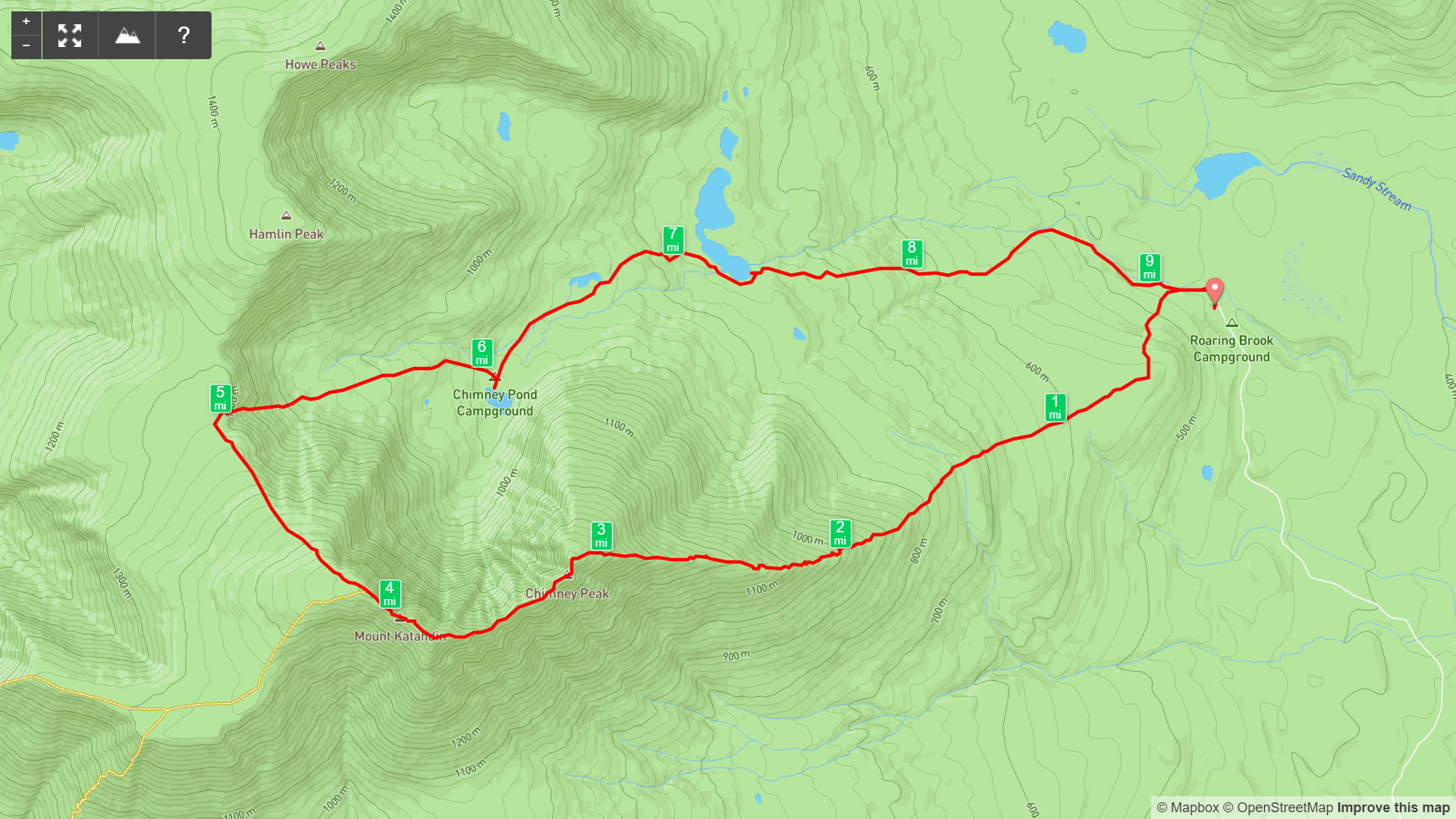
Map of Mt Katahdin Loop from Roaring Brook Campground, Baxter State Park
Elevation Profile of Mt Katahdin Loop from Roaring Brook Campground, Baxter State Park
Overview. Katahdin is the iconic hike in Maine and the famous location of the northern terminus of the Appalachian Trail. The prominence of this mountain is nothing short of stunning, and while the views are spectacular, the real beauty of this hike is its relentlessness physicality - a true hiker’s hike.
Route Type | Loop
Total Distance | 9.3 miles
Elevation Gain | 3,921 feet
Overall Difficulty | Strenuous with Class 2/3 Scrambling
GPS Waypoints
Roaring Brook Trailhead | 45.919336, -68.857575
Pamola Peak | 45.906189, -68.906053
Baxter Peak | 45.904406, -68.921392
Katahdin Section Map
Baxter State Park Map
Parking. Roaring Brook Campground has a large parking lot for permitted overnight and day use visitors. Be sure to secure a permit early to enjoy this hike. [Baxter State Park Website]
Trail navigation. The trail is incredibly well marked and maintained. Take Roaring Brook Trail past the ranger station and fork left to begin ascending Helon Taylor Trail. From there, make your way through the forest before finally breaking treeline where some scrambling awaits you. Continue your ascent - taking in views along the way - until finally reaching Pamola Peak. Continue onto the Knife Edge from here taking particular care at the bottom of Chimney Peak. This is a potentially dangerous spot, so pay attention. Continue across the Knife Edge until topping out at Baxter Peak. When ready, continue on the rock scrabble trail to reach Saddle Trail on the right (east). This is a fantastic place to destroy an ankle, so take extra care to focus on your footsteps and keep left to follow the blazed trail. Avoid getting into the loose stuff, as this can knock rocks down onto other hikers. Once below treeline, continue descending until reaching Chimney Pond. Do NOT enter the water - it is the main water source for campers and day hikers. Continue the descent passing a couple more ponds before finally reaching the parking lot.
PERMIT REQUIRED - Lottery System. Baxter State Park was a gift to the people of Maine and is a conservation over recreation park (the exact opposite of how virtually every state park in the country is managed). That means that permits are limited and a lottery system is in effect. Maine residents get first dibs and out of state folks get what’s left.
HIKER NOTE - Camp and Alpine Start. We used a day permit to hike Katahdin that doesn’t open until after sunrise and were slow to reach the peaks. Camp in Baxter the night before your hike and get an early start at least a couple hours before first light. This will provide better odds of making the summits before afternoon clouds develop.
CAUTION - Class 2/3 Scrambles. This hike features extensive scrambling with nearly all of it being Class 2. Between Pamola and Chimney Peaks, there is a small Class 3 section at the base that is a little dicey.
CAUTION - Rock Slide. Saddle Trail was used to descend and is a trail built immediately adjacent to a rockslide. Follow the blazes on descent-left for more stable footing and to reduce risk of kicking rocks on hikers below.
CAUTION - Cliffside. Take care not to get too close to the edges of cliffs at the summit. Careless steps can be costly here.
CAUTION - Be Bear Aware. Black bear are plentiful in the region. Know Before You Go => US Forest Service Black Bear Safety Tips
CAUTION - Moose. There were plenty of moose droppings lining the trail. Be aware and never approach moose. Leave a wide berth and turn back if needed.
The Morning Line-up for Day Permit Holders, Baxter State Park
Check-in and Permit Verification, Baxter State Park
Main Trailhead at Roaring Brook Campground, Baxter State Park
Sign to Ranger Cabin, Baxter State Park
Ranger Cabin and Sign-in Station, Baxter State Park
Go Toward Chimney Pond Trail, Baxter State Park
Sun Popping Over Roaring Brook, Baxter State Park
Small Cascades on Roaring Brook, Baxter State Park
Helon Taylor Trail Split, Baxter State Park
A Little Trail History, Baxter State Park
The First of Countless Scrambles, Baxter State Park
First Views from Helon Taylor Trail, Baxter State Park
First Views North Toward Hamlin Peak, Baxter State Park
Looking Out to the Turners, Baxter State Park
North Turner from Around a Boulder, Baxter State Park
First Views of the South Rim of Katahdin, Baxter State Park
“The Rock Pile” - Local Name for Mt. Katahdin, Baxter State Park
Baxter Peak from Pamola Peak, Baxter State Park
Signage at Pamola Peak, Baxter State Park
The Path to Baxter Peak on the Knife Edge, Baxter State Park
Descending the Chimney, Baxter State Park
Looking Into Chimney Pond Basin from the Base of the Chimney, Baxter State Park
Looking Back at Pamola Peak, Baxter State Park
The Knife Edge with Marked and Well Worn Rock Trail, Baxter State Park
Final Stretch to Baxter Peak, Baxter State Park
Looking Back at the Knife Edge and Pamola Peak, Baxter State Park
The Top of Mt. Katahdin, Baxter Peak, Baxter State Park
Long Weathered Trail Sign for Saddle Trail, Baxter State Park
View from the Top of Saddle Trail, Baxter State Park
Saddle is Cut Rock Trail Adjacent to a Rock Slide, Baxter State Park
Chimney Pond and a Clouded Up Mt. Katahdin, Baxter State Park
Narrow View from Dry Pond, Baxter State Park
Looking Back at Mt. Katahdin from Basin Ponds, Baxter State Park
Plenty of Water Below the Peaks, Baxter State Park
Katahdin is Serious Business, Set a Turnaround Time and Stick to It!!!


